


The year of 2020 has seen record-setting fires in the west. With the early start of intense wildfire activity this season, it is entirely possible that devastating fires will continue well into the fall. In addition, with the COVID-19 pandemic occurring simultaneously, communities face additional challenges in managing wildfire.
While we may not be able to stop these fires from occurring, we can accelerate our recovery by understanding and managing the risk.
What has happened so far this wildfire season?
With over 2.5 million acres burned to date, 2020 has already surpassed all previous wildfire seasons in California for acreage burned. In recent years, large and destructive fires have burned well into November and December. It is likely that the state will see a continuation of extreme wildfires for the next several months.
The most recent outlook from the Climate Prediction Center for August through November indicates that drought conditions are likely to persist over nearly the entire southwestern U.S. from Wyoming and Colorado all the way through northern and southern California.
Just in the last month, the SCU Complex (over 396,000 acres and 224 structures destroyed) and the LNU Complex (over 375,000 acres and 1,030 structures destroyed) became the second and third largest fires in California history, respectively. Fortunately, the firefighting crews have achieved greater than 95% containment on both fires. However, new fires have already flared up throughout the state and are forcing tens of thousands of residents to evacuate.
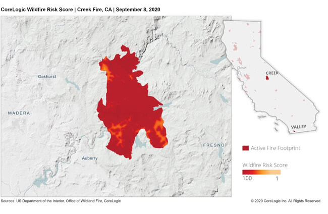
The Creek Fire in Fresno and Madera counties has burned through more than 175,000 acres. Over the Labor Day weekend, a camping area in the Sierra National Forest had to be evacuated by helicopter after more than 200 people were trapped by the encroaching fire. To date, over 350 structures have been damaged or destroyed by the Creek Fire, and dozens of mandatory evacuation areas have been identified by CAL FIRE and the U.S. Forest Service (USFS).
Farther north, the North Complex Fire, a combination of several smaller fires that have been burning since mid-August, exploded during the night of September 8 and grew from 40,000 to over 250,000 acres in less than 48 hours. This rapid progression took residents by surprise, causing hasty evacuations, at least three deaths, and the burning of over 2,000 structures.
The August Complex Fire in the Coast Range of Northern California has burned through over 746,000 acres making it the largest fire in California history. The fire started as 38 separate fires ignited by lightning strikes in mid-August. There have now been over 25 structures destroyed.
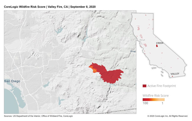
In southern California, the Valley Fire east of San Diego has burned over 17,000 acres and destroyed over 10 structures. Moreover, the El Dorado Fire east of San Bernardino has burned over 9,600 acres. The fire began due to fuels that ignited when a pyrotechnic device was placed in a field of tall, dry grass and ignited during a gender reveal party. As with any type of errant spark or flame that people can cause, the amount and severity of destruction from a seemingly innocuous device can be disastrous when conditions are ripe for wildfires to occur.
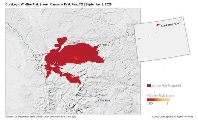
Colorado has also had several fires recently. The Pine Gulch Fire in August became the largest in state history with over 139,000 acres burned. The Cameron Peak Fire expanded to over 100,000 acres over Labor Day weekend, making it one of the largest fires in Colorado history. Suppression of this fire has been especially challenging due to 40 mile per hour winds that are limiting the deployment of aircraft.
Wildfire is unique as a type of natural catastrophe in that it is often caused by human ignition and its spread can be dramatically hindered by fire suppression. About 80% of fire ignitions are started by people, and these two human factors make wildfire damages particularly challenging to predict.
Over the last 15 years, CoreLogic has been evaluating the risk of wildfire to individual properties. 15 states account for 93% of all wildfire acreage per year and over 98% of wildfire-related property losses. These states include nearly 2 million single family residence homes and a whopping 638 billion dollars in reconstruction value.
By including the risk associated with embers that come from distant fires, the full spectrum of the risk is being captured.
Which areas are the most at-risk to extreme wildfires?
With climate change bringing hotter environments, one can expect an increasing frequency of large and destructive wildfires overall. Some regions, more than others, are especially sensitive to these changes.
Which fires cause most of the damage in California?
When using the CoreLogic U.S. Wildfire Model on RQE® to simulate millions of fires of every frequency, size and impact on the 14 million properties in California, results indicated that most of the fires that affect California properties are less than 50,000 acres in size.
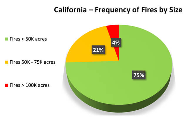
Only 4% of the fires that cause any damage are large fires (over 100,000 acres in size), while 75% of fires that cause any damage are small fires (under 50,000 acres in size). However, when comparing this with the number of homes burnt by fire size, it’s clear that these large fires are causing 35% of the damage statewide.
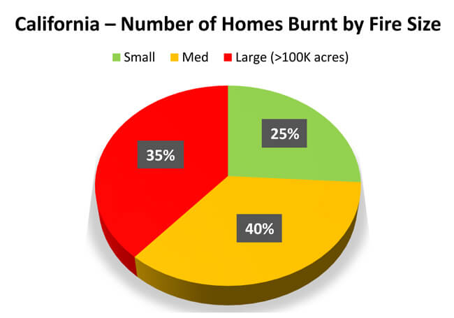
Small fires are only causing 25% of the damage statewide, while the rare, extreme events that happen 4% of the time are causing 35% of the losses in the state. These extreme fire events are the ones most susceptible to the impacts of climate change.
How can we target high risk areas for fire mitigation?
One of the key drivers of wildfire growth is the flow of air with strong winds. On the west coast, dry winds coming from inland play a significant role in the growth of wildfires. Ridges and mountains, being barriers to the natural movement of air, can constrain the growth of wildfires. These ridges and mountains are separated by drainage basins, where precipitation collects and drains into rivers or other bodies of water. We can use the boundaries defined by the U.S. Geological Survey (USGS) hydrological unit codes (HUC 8) to break California into pieces separated by drainage sub-basins.
By using the outlines of river basins, California can be broken into small regions and better understand which areas are the most at-risk to large wildfires. This way, fire mitigation efforts can be focused on the areas with the highest risk.
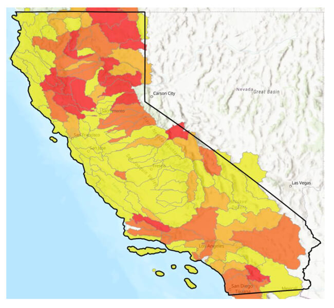
The red areas are where more than half the damage comes from large fires, and the yellow areas are where there is the least damage from large fires. Some regions are more susceptible than others due to factors such as local vegetation, climate, access to effective fire suppression, and percentage of homes in the Wildland Urban Interface (WUI). The WUI is an area where residential and urban development comes into contact with wildland vegetation. If these large river basins are divided into smaller sub zones, risk can be analyzed at more granular level.
Red areas are the most sensitive to the increasing frequency of large fire events that will come with climate change. Mitigation efforts, such as hardening of the roof or property perimeter, can make the most impact in these regions. By using models that simulate fires of every size and frequency, one can determine the characteristics of the riskiest areas and know where to focus resources.
The impact of COVID-19 on the 2020 wildfire season
One of the biggest problems of the pandemic with respect to disaster prevention and mitigation is that it is posing a serious threat to our ability to prepare for and stop the spread of wildfires. 1 in 3 homes are currently located in high wildfire risk areas in the WUI.
This is especially problematic for the west coast where most of the property damage from wildfire occurs. As states are moving to position their firefighting assets in the most critical locations, officials are finding that COVID-19 quarantine measures have resulted in significant staff shortages for fire suppression management. Many fire academies this year were canceled, such as in Washington state where three of their canceled fire academies were meant to train 4,500 firefighters.
Additionally, wildfire management sites, which are typically high in density with poor sanitary conditions, are making virus transmission more likely. Many firefighters have already caught the virus. In early April, 10% of the local fire department in San Jose was exposed to the virus. Lower staffing could mean that many of these firefighters will have to work on fires for 40-45 days with no breaks. The pandemic combined with drought conditions throughout the west is making this year an especially tough one for fire management.
In conclusion
With an evolving climate, we must continually improve and adapt how we manage the risk of wildfire. We cannot control the occurrence of a devastating fire, but we do have the data and analytics to expand our understanding of what can happen. Better knowledge can help us build a more resilient future.
At CoreLogic, our engineers, scientists and risk planners are committed to helping people and properties in harm’s way to prepare for events like the devastating wildfires of 2017 and 2018 — and for what’s still to come this year. Our modeling and forensic evaluation solutions provide critical insights into how we can prepare for these events and where we can best deploy resources afterwards to achieve a less catastrophic tomorrow.
For more trusted insights on wildfires using intuitive CoreLogic data, check out our Wildfire Risk or U.S. Wildfire Model page.
2020 © CoreLogic, Inc. All rights reserved.

