1. 7,201,572 single- and multifamily residences in Hurricane Ian’s path with high flash flood risk
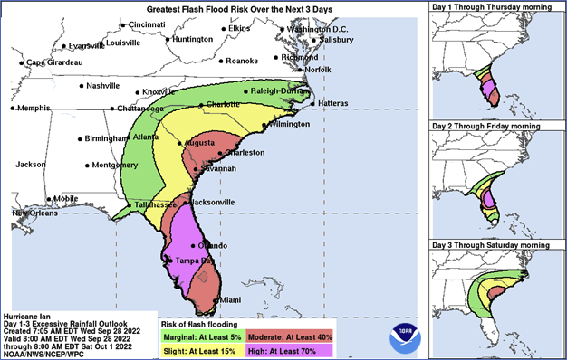
- The National Hurricane Center (NHC) currently forecasts that the entire state of Florida is at some level of flash flood risk due to heavy rainfall from Hurricane Ian. Most of the state is at moderate (40%) or greater risk. The cities of Tampa Bay and Orlando have a 70% chance of flash flooding (Figure 1).
- CoreLogic estimates that 7,201,572 single- and multifamily residences (SFRs and MFRs) with a combined total reconstruction value (RCV) of $1.6 trillion are within the “moderate” and “high” flash flood risk bands, as forecasted by NHC (Figure 1). Note, this does not indicate that every single home within these bands will flood, nor that any flooded home will sustain 100% damage up to its full RCV. This estimate accounts for flash flooding only and excludes homes that at risk to riverine and coastal flooding.
Figure 1: Hurricane Ian 1 to 3-day flash flood risk valid September 28 – October 1.

Source: NHC 2022
© 2022 CoreLogic,Inc., All rights reserved.
2. Hurricane Ian Is a Unique Storm, a Mixing Hurricanes Irma, Katrina and Andrew
- Many have used Hurricane Charley in 2004 as a historical analog for Hurricane Ian, but despite similar strength and landfall location, the two storms are very different. First, Hurricane Ian is much larger, with a wind field that is more than double that of Hurricane Charley. Second, Hurricane Ian is moving forward more slowly; Charley made landfall at more than twice the speed of Ian. Both factors have significant impacts on not only the number of homes that will experience hurricane-force winds across Florida, but these factors will greatly magnify the storm surge and precipitation-induced inland flooding.
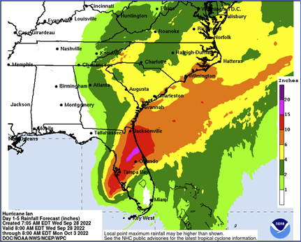
- Hurricane Ian’s impact on Florida residents appears to be a worst-case scenario, combining the most dangerous components of three infamous U.S. landfalling hurricanes: Andrew (1992), Katrina (2004) and Irma (2017). Hurricane Ian made landfall in a densely populated area with major hurricane-force winds and is expected to remain at hurricane status (with windspeeds over 74 mph) for hours impacting thousands of homes across the entire state. Storm surge depths of up to 18 feet above the ground surface may flood thousands of homes. Finally, constant and often torrential downpours will inundate the relatively flat state of Florida for several days after landfall. As of Sept. 28, five-day rainfall depths of up to 20 inches (Figure 2) are expected across portions of the state.
Figure 2: 5-day U.S. rainfall totals (forecasted) valid September 28 – October 3.

Source: NHC 2022
© 2022 CoreLogic,Inc., All rights reserved.
© 2022 CoreLogic,Inc., All rights reserved.

