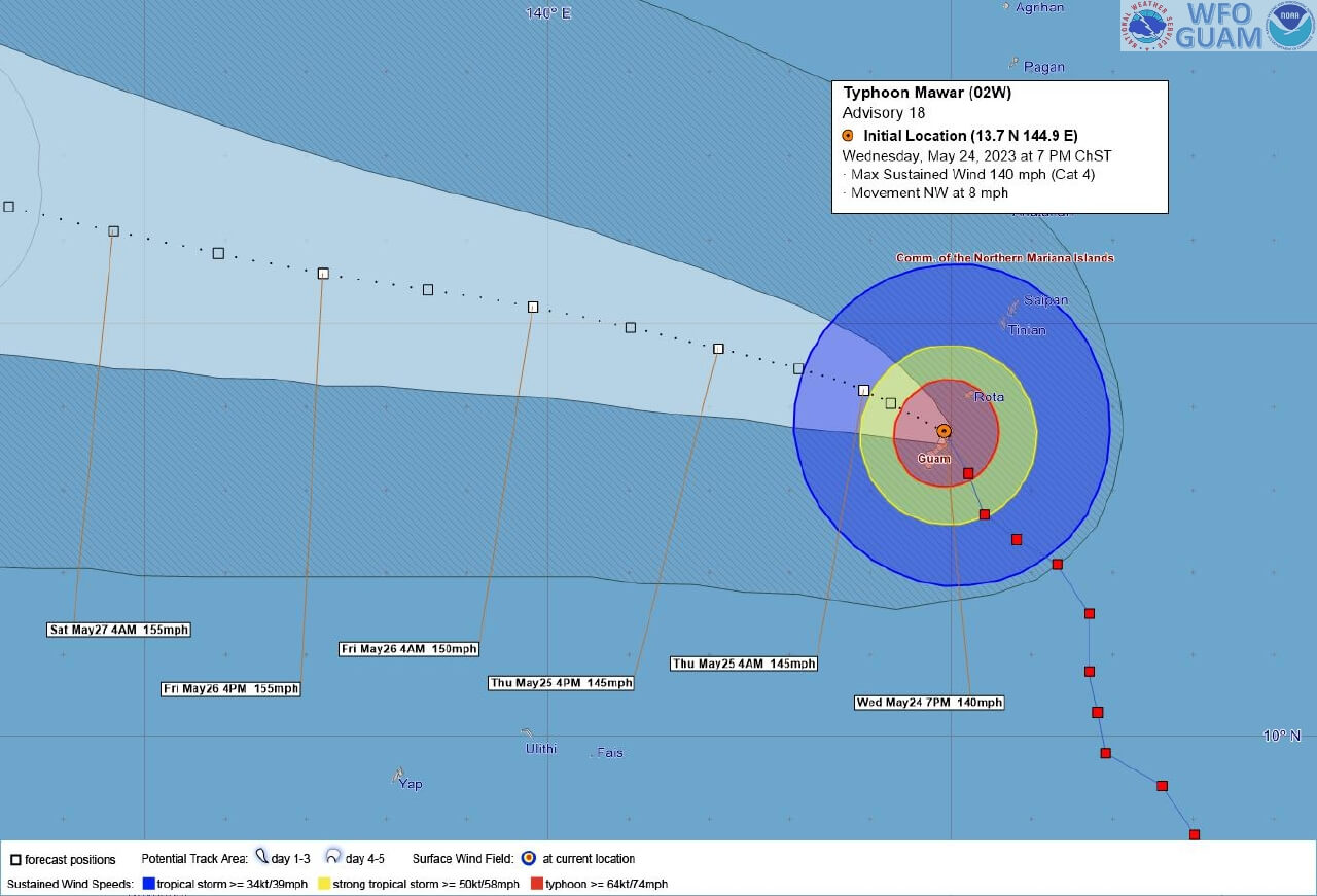
Typhoon Mawar (02W) passed between the U.S. territory of Guam and Rota, the southernmost island of the Northern Mariana Islands, on Wednesday, May 24 between 7:00-8:00 p.m. local time (9:00-10:00 a.m. GMT). According to the National Weather Service (NWS) station in Guam, the southern eyewall of Mawar pivoted over Guam.
Maximum sustained windspeeds of 140 mph were estimated via radar near the eyewall; typhoon-force winds (greater than 74 mph) extended approximately 45 miles, spanning the entire island (Figure 1). The storm continues to track west-northwest at 8 mph, which will subject buildings in Guam and Rota to typhoon-force winds for an extended period of time.

Typhoon Mawar is the equivalent of a Category 4 tropical cyclone on the Saffir Simpson Hurricane Intensity Scale.
In addition to Category 4 winds, Mawar brought torrential downpours and life-threatening storm surge to Guam. The island of Guam is expecting to see 10 to 15 inches of rain over a 24-hour period, with localized instances of up to 25 inches. Flash flooding and coastal erosion are possible along the coastline. Storm surge depths of 5 to 10 feet are possible on Guam’s northern tip, Ritidian Point. In Apra Harbor, surge depths up to 4 feet are expected.
Tropical storm conditions (wind speeds greater than 39 mph) are possible in Tinian and Saipan to the north.
The Building Landscape in Guam
Typhoon-force winds will cause considerable damage to buildings constructed with lighter materials, including extensive damage to non-concrete roofs. Buildings constructed using concrete will be less vulnerable to typhoon-force winds.
According to the U.S. Census Bureau 2020 Decennial Census of Island Areas, there are approximately 43,300 occupied housing units in Guam. Guam adopted more advanced residential building code requirements in the mid-20th century following Typhoon Karen in 1962 and Typhoon Pamela in 1976. Guam established a minimum basic wind load design speed requirement of 155 mph for residential structures, which proved effective during Typhoon Omar in 1992. Other design features in the Guam building codes include more resilient construction materials (e.g., concrete) and window/door protections (e.g., hurricane shutters). These advanced building code standards should mitigate some residential damage in Guam.
The primary economic sectors in Guam are military spending and tourism. Guam is home to two U.S. military bases; a naval base in Santa Rita and the Andersen Air Force Base in Yigo. The Guam Army National Guard has facilities on the island as well. The tourism industry generates approximately $260 million in government revenue, according to the Guam Visitors Bureau. Guam is home to multiple luxury resorts and hotels, particularly along the coastline where wind and storm surge was the most severe.
Notable Typhoons in Guam
There are several historical examples of typhoon activity resulting in extensive damage to Guam.
In December 2002, Guam sustained heavy damage when Typhoon Pongsona passed between Guam and Rota with maximum sustained windspeeds of 144 mph and gusts up to 173 mph, according to the National Oceanic and Atmospheric Administration (NOAA) NWS Service Assessment. Damage totals in Guam from Typhoon Pongsona exceeded $700 million (in 2003 dollars). In 1997, Super Typhoon Paka generated windspeeds of 185 mph on the island, according to the NWS post-event assessment. The damages resulting from this event totaled approximately $580 million (in 1998 dollars).
Future Updates
Typhoon Mawar is forecasted to continue west-northwest. Typhoon-force winds are expected to remain over the next several days. The long-term forecast from the Joint Typhoon Warning Center (JTWC) Warning #18 indicates that Mawar will travel towards the northern Filipino islands and Taiwan.
CoreLogic Command Central will continue to monitor Typhoon Mawar. If Typhoon Mawar makes another landfall in Taiwan, the Philippines or Japan, CoreLogic Command Central may issue proxy events and modeled industry loss estimates from its Asia Typhoon Model.
Visit www.hazardhq.com for updates and information on catastrophes across the globe.


