A Lesson for Communities Everywhere
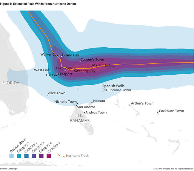
Hurricane Dorian, the strongest tropical cyclone to ever to hit the Bahamas, impacted the islands with hurricane-force winds from September 1 to 3 of 2019. Dorian was a Category 5 storm with maximum sustained winds of 185 mph, the strongest of which affected the northern Bahamian islands of Grand Bahama and Abaco along with several smaller nearby islands. Nassau, Bahamas’ capital city, was spared from the most devastating winds despite having the greatest exposure in the country. Still, the impact across the islands was extreme – especially the devastating scale of lives lost.
Considering the Bahamas’ vulnerable location (southeast of Florida in the Atlantic Ocean), its hurricane risk is severe, and the island was, at the time, still suffering from the losses of hurricanes Joaquin (2016), Matthew (2016) and Irma (2017). According to the Inter-American Development Bank (IDB)[1], the losses from these three hurricane events totaled $750 million.

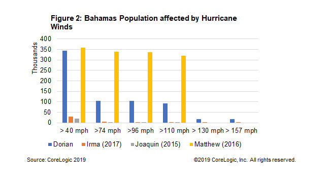
According to research, Dorian was not an abnormal storm for the area. A summary review of hurricanes in the Atlantic basin since 1900 identifies 23 storms that likely produced Category 3 (or stronger) winds on one or more of the Bahamian islands, while eight storms likely produced Category 4 winds or stronger. Hurricane winds vary by location as the storm traverses the region, sometimes making it difficult to analyze affected areas. To help alleviate this challenge it’s useful to look at areas where the population was greatly affected in order to pinpoint wind strength. Evaluating the wind field of Dorian against the population of the Bahamas helps us determine how broadly the impacts are felt throughout the island. Tropical storm-force winds affected most of the populace, with about 25% of the population experiencing major (Category 3 or higher) hurricane strength winds.

Comparing the breadth of Dorian to Matthew helps us understand the damaging effects of Dorian. While the former hurricane impacted the Bahamian populace with the strongest winds, Matthew affected a larger populace. And while the damage from Matthew was more widespread, Dorian’s damage to the Abaco and Grand islands was more severe.
Insurance regulators in the Bahamas report spending $360 million in general insurance due to Dorian’s impact – 67% ($240 million) being property insurance that likely covers hurricane wind damage.[3]
The islands impacted by Dorian are isolated – Freeport is 125 miles northeast of Nassau while Marsh Harbour is 100 miles northwest from the capital. Isolation may increase reconstruction costs compared with other natural disasters. We’ve seen this most recently with the California wildfires of 2017 and 2018. Excluding the recoveries from insurance payouts, the increased costs can lead to shortfalls during reconstruction, which can lead to a prolonged recovery period and out-migration.
The frequency of hurricane winds in the Bahamas promotes the case for strengthening infrastructure for both residential and commercial structures. But the severity of the island’s losses is a strong case for reconstruction capital – a need usually covered by insurance. This is a lesson that can be translated to communities in the United States and elsewhere, especially as we see increasing losses from the perils of natural disaster.
For more information, visit our catastrophe event response site Hazard HQ or contact your account executive to learn more.
©2021 CoreLogic, Inc. , All rights reserved.
[1] Wright, A. “Development Challenges in the Bahamas”. Inter-American Development Bank Policy Brief IDB-PB- 276, May 2018.
[2] IMF 2019. Purchasing Power Parity, international dollars
[3] https://insurancecommissionbahamas.com/wp-content/uploads/2019/07/2018-Annual-Report.pdf


