August 20, 2021 | 3:31 pm CT
Tropical Storm Henri is gradually strengthening
- Tropical storm Henri continues to gradually strengthen and is currently located in the SW Atlantic or approximately 320 miles SSE of Cape Hatteras North Carolina.
- Current maximum winds speeds are sustained at 70 mph, just shy of hurricane strength.
- Tropical storm Henri is forecasted to continue to strengthen and become a hurricane by Saturday morning.
- Hurricane, tropical storm and storm surge watches have been issued for portions of the North Eastern U.S./New England.
The greatest threat from Henri will be storm surge
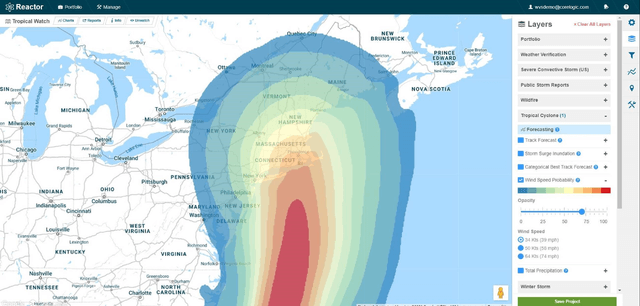
- Henri is forecasted to accelerate on Saturday towards the north and make landfall as a strong tropical storm or Category 1 hurricane in southern New England on Sunday afternoon.
- Several numerical weather prediction models as of Friday morning continue to shift Henri slightly further westward as he nears landfall closer to central Long Island.
- The greatest threat from Henri will be storm surge in excess of 5-7ft in some areas.
- Maximum storm surge threat is largely dependent on the ultimate strength and landfall location but currently appears to be from the Central NJ coast, through Long Island up to Cape Code/Nantucket.
- Secondary threats include strong winds (maximum gust to 70-80mph) and fresh water flooding from rainfall in excess of 6-8”.
Henri is tracking to impact a high population density area
- Though Henri will likely not reach major hurricane status significant impacts are looking more likely given the high population density of the North Eastern U.S. coast.

© 2021 CoreLogic,Inc., All rights reserved.


