—Reconstruction cost value of all homes in the August 29 cone of uncertainty totals nearly $144.6 billion—
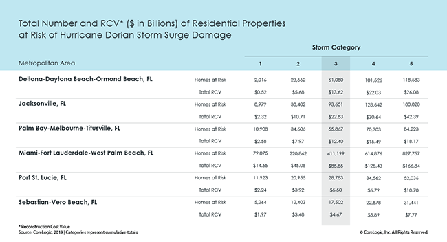
CoreLogic® (NYSE: CLGX), a leading global property information, analytics and data-enabled solutions provider, today released data analysis showing 668,052 single-family and multifamily homes along the east coast of Florida with a reconstruction cost value (RCV) of approximately $144.6 billion are at potential risk of storm surge damage from Hurricane Dorian based on its projected Category 3 status at landfall. These estimates are based on the Thursday, August 29 National Hurricane Center 5:00 p.m. EDT forecast.
As Hurricane Dorian approaches Florida, its path will become more certain and the below metropolitan areas at risk will narrow. For the most up-to-date storm surge exposure estimates, visit the CoreLogic natural hazard risk information center, Hazard HQ™, at www.hazardhq.com.

The table above indicates the total number of homes with exposure to storm surge damage given the current path of the storm, and the RCV figures assume 100 percent destruction of all at-risk homes – and represents the worst case scenario.
Hurricane-driven storm surge can cause significant property damage when high winds and low pressure cause water to amass inside the storm, releasing a powerful rush over land when the hurricane moves onshore. For a complete view of total storm surge risk for all Atlantic and Gulf Coast states metropolitan areas, download the 2019 CoreLogic Storm Surge Report.
Methodology
CoreLogic offers high-resolution location information solutions with a view of hazard and vulnerability consistent with the latest science for more realistic risk differentiation. The high-resolution storm surge modeling using 10m digital elevation model (DEM) and parcel-based geocoding precision from PxPoint™ facilitates this realistic view of risk. Single-family residential structures less than four stories, including mobile homes, duplexes, manufactured homes and cabins (among other non-traditional home types) are included in this analysis. Multifamily residences are also included. This is not an indication that there will be no damage to other types of structures, as there may be associated wind or debris damage and are not tabulated in this release.
Source: CoreLogic
The data provided are for use only by the primary recipient or the primary recipient’s publication or broadcast. This data may not be resold, republished or licensed to any other source, including publications and sources owned by the primary recipient’s parent company without prior written permission from CoreLogic. Any CoreLogic data used for publication or broadcast, in whole or in part, must be sourced as coming from CoreLogic, a data and analytics company. For use with broadcast or web content, the citation must directly accompany first reference of the data. If the data is illustrated with maps, charts, graphs or other visual elements, the CoreLogic logo must be included on screen or website. For questions, analysis or interpretation of the data, contact Chad Yoshinaka at [email protected] or Caitlin New at [email protected]. Data provided may not be modified without the prior written permission of CoreLogic. Do not use the data in any unlawful manner. This data is compiled from public records, contributory databases and proprietary analytics, and its accuracy is dependent upon these sources.
About CoreLogic
CoreLogic (NYSE: CLGX), the leading provider of property insights and solutions, promotes a healthy housing market and thriving communities. Through its enhanced property data solutions, services and technologies, CoreLogic enables real estate professionals, financial institutions, insurance carriers, government agencies and other housing market participants to help millions of people find, acquire and protect their homes. For more information, please visit www.corelogic.com.
CORELOGIC, the CoreLogic logo, PxPoint and Hazard HQ are trademarks of CoreLogic, Inc. and/or its subsidiaries. All other trademarks are the property of their respective owners.